South Dakota Population 2013

south-dakota-population-2013South Dakota Population 2013

The United States Census Bureau estimates that the population of South Dakota in 2013 was 833,354, which is ranked the 46th largest population in the United States. This estimate shows a 2.4% increase since the last census in 2010, also conducted by the United States Census Bureau. The population density of the state is 10.9 people per square mile, ranked 46th largest density in the United States.

South Dakota Population Projections

The population of South Dakota has been increasing at a rate much higher than the rest of the United States. All projections and predictions for the future population of the state are no longer valid due to the unexpected increase in the population.

South Dakota Land Mass

The state of South Dakota is approximately 380 miles long and 210 miles wide with a square area of 77,121 square miles, making it the 17th largest state in the Untied States. Of the 77,121 square miles, only 1,224 square miles are covered by water. The highest point in the state of South Dakota is Harney Peak, which is 7,242 feet above sea level. The lowest point in the state is at Big Stone Lake, which reaches 966 feet above sea level. The geographic center of South Dakota is located in Hughes County, 8 miles northeast of Pierre. South Dakota is bordered by six states: North Dakota, Minnesota, Iowa, Nebraska, Wyoming, and Montana.

South Dakota can be broken up into four distinct geographic land areas: the Drift Prairie, the Dissected Till Plains, the Great Plains, and the Black Hills. The Drift Prairie covers the majority of the eastern portion of the state. It has many low hills and glacial lakes. The Dissected Till Plains are in the southeastern corner of the state. This area has many rolling hills that intertwine with streams. The Great Plains covers most of the western two-thirds of the state. This area has many hills, canyons, buttes, and plains. It is also home to the Badlands and the Badlands National Park. Lastly, the Black Hills is in the southwestern portion of the state. This area has many mountains and it also has the highest point in the state. The Black Hills is the part of the state full of rich minerals, especially gold. Mt. Rushmore can be found in the Black Hills.

South Dakota Demographics

Of the approximate 0.917 million people in the state of South Dakota, about 49.8% of the population is female, while 50.2% is male. Also, approximately 86% of the population identifies as white (including Hispanic or Latino). But, out of that 86%, only about 3% do identify as Hispanic or Latino and the other 83% as Caucasian. Those that identify as Black or African American make up 2% of the entire population of the state of South Dakota. The American Indian and Alaskan Native populations make up approximately 9% of the entire population of the state. The rest of the population is made up of those that identify as Asian, Native Hawaiian, other Pacific Islanders, or those that identify as two or more races. These other races make up only about 3% of the South Dakota population.

South Dakota Religion

The population of South Dakota identifies as religious at a higher rate than the national average. About 59% of the state population identifies as religious, compared to the national average of 49%. Out of the 59%, about 20% identify as members of the Lutheran Church, making it the largest denomination in South Dakota. The next largest denomination in the state is Catholic at about 18% of the population. All the other Christian denominations make up about 20.8% of the population. Those who identify as Jewish, Islamic, or as an Eastern religion only make up 0.2% of the population.

An American Journey in South Dakota

south-dakota-population-2013-rushmore
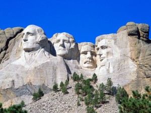
South Dakota Mount Rushmore

Mount Rushmore, the President’s Mountain, is located in the Black Hills of South Dakota. Mt. Rushmore stands as a shrine of democracy, a monument and memorial to this country’s birth, growth and ideals. Mount Rushmore symbolizes the greatness of this nation through the greatness of its leaders. The epic sculpture of Mount Rushmore depicts the faces of four exalted American presidents that symbolize this nation’s rich history, rugged determination and lasting achievements. The four faces on Mount Rushmore from left to right as you face it are:

  • George Washington
  • Thomas Jefferson
  • Theodore Roosevelt
  • Abraham Lincoln

South Dakota Economy

The unemployment rate in the state of South Dakota is 4%, which is consistently lower than the previous unemployment rates in the state. This is compared to the national average of 7.6% unemployment. The ethanol industry is a very large part of the economy of the state and of the country. It contributed $3.8 billion to the economy in 2012. The most important minerals mined in the state are petroleum granite, and limestone. South Dakota also accounts for 4% of the country’s cattle production.

Other Resources

If you would like to learn more about South Dakota click here.

Kansas Population 2013

Kansas Population 2013

The United States Census Bureau estimates that the population of Kansas in 2013 was 2,888,905, which is ranked the 33rd largest population in the United States. This estimate shows a 1.1% increase since the last census in 2010, also conducted by the United States Census Bureau. The population density of the state is 35.1 people per square mile, ranked 40th largest density in the United States.

Kansas Population Expectancy

Based on a study done by the Center for Economic Development and Business Research, if the migration patterns remain the same in the state, then by the year 2040, the population will grow at an annual rate of 0.48% and reach approximately 3.24 million people in the state of Kansas. However, if there is no migration at all, then the population will increase at an average annual rate of 0.45% and reach approximately 3.22 million people.

Kansas Land Mass

The state of Kansas is approximately 400 miles long and 210 miles wide with a square area of 81,823 square miles, making it the 15th largest state in the Untied States. Of the 81,823 square miles, only 459 square miles are covered by water. The highest point in the state of Kansas is Mount Sunflower, which reaches 4,039 feet above sea level. The lowest point in the state is the Verdigris River, which reaches 679 feet above sea level. The geographic center of Kansas is in Barton County, northeast of the Great Bend. Kansas is bordered by four states in total: Nebraska, Oklahoma, Missouri, and Colorado.

Kansas Demographics

Of the approximate 2.89 million people in the state of Kansas, about 50.3% of the population is female, while 49.7% is male. Also, approximately 87% of the population identifies as white (including Hispanic or Latino). But, out of that 82%, about 11% do identify as Hispanic or Latino and the other 71% as Caucasian. Those that identify as Black or African American make up only 6% of the entire population of the state of Kansas. The rest of the population is made up of those that identify as Asian, American Indian, Alaskan Native, Native Hawaiian, other Pacific Islanders, or those that identify as two or more races. These other races only account for approximately 7% of the entire population of the state of Kansas.

Kansas Religion

The population of Kansas identifies as religious at only a slightly higher percentage than the national average. About 51% of the state population identifies as religious, compared to the national average of 49%. Out of the 51%, about 15% identify as Roman Catholic, making it the largest denomination in the state of Kansas. Those that identify as Baptist make up the next largest denomination with about 10% out of the total 51%. Those that identify as some form of Christian denomination other than Catholic make up 35% out of the 51%. However, those that identify as a participant in a religion other than Christianity (Judaism, Islam, or Eastern religions) make up only about 1% out of the total 51%.

Experience the Natural Kansas

kansas-population-2013-economyKansas Economy

The trade, transportation, and utilities sector of the private sector is the largest employer in the state of Kansas. 23% of those employed in the state work for this sector. The next largest sector is education and health services at 17% of the employed population. However, those who work in the professional and business services and manufacturing sectors come in close to the education and health services sector at 15% and 14% respectively.

Over the last few years, Kansas’ unemployment rate has begun to decrease, along with the national unemployment rate. The Kansas unemployment rate has steadily been less than the national unemployment rate, except for 2004 and 2005 when they were about the same rate. The unemployment rate is projected to continue to decrease over the next year. Over the last year, there has been progress in terms of ratio of job seekers to job openings in the state of Kansas. The rate has improved from 3.2 job seekers for every job opening in Kansas to recently 2.5 job seekers for every opening in Kansas. The most vacant occupation in the state of Kansas is the combined food preparation and serving workers, including fast food. It has the most vacancies over the other occupations by almost double. There are approximately 3,000 job openings for this field, compared to the next highest amount of vacancies, which is for waiters and waitresses, at about 1600 openings.

Alabama Population 2013

alabama-population-2013Alabama Population 2013

The United States Census Bureau estimates that the population of Alabama in 2013 was 4,822,023, which is ranked the 23rd largest population in the United States. This estimate shows a 0.9% increase since the last census in 2010, also conducted by the United States Census Bureau. The population density of the state is 94.7 people per square mile, ranked the 27th largest density in the United States. The population of Alabama is expected to reach approximately 5.2 million people by the year 2025, which is an approximate 7.8% increase from the current population.

Alabama Land Mass

The greatest distance from east to west of the state of Alabama is 210 miles, and the greatest distance from north to south is 329 miles. It has an approximate square area of 52,423 square miles, making it the 30th largest state in the country. Of the 52,423 square miles, 1,673 square miles are covered by water. The highest point in the state of Alabama is Cheaha Mountain, which is 2,407 feet above sea level. The lowest point in the state is at the Gulf of Mexico, which reaches sea level. The geographic center of Alabama is located in Chilton County, 12 miles southwest of Clanton. Alabama is bordered by four states: Tennessee, Florida, Mississippi, and Georgia. The Gulf of Mexico borders the southern portion of the state.

Alabama can be broken up into five distinct geographic land areas: the East Gulf Coastal Plain, the Piedmont Upland, the Alabama Valley and Ridge, the Cumberland Plateau, and the Highland Rim. The East Gulf Coastal Plain makes up the majority of the state with differing types of landscapes. The southwest portion of the state has low and swampy areas. The southeastern portion is an important farming area. The northern portion is often times called the Central Pine Belt due to the many pines trees and hilly regions. The Black Belt Prairie is the portion that divides the Northern and Southern parts of the Gulf Coastal Plain. It used to be home to one of the country’s largest plantations due to the quality of the soil to grow cotton. The Piedmont Upland is in the eastern central section of the state, made up of low hills and sandy valleys. This area is also full of minerals and the highest point in the state. The Alabama Ridge and Valley is to the northwest of the Piedmont and it is made up of sandstone ridges and fertile limestone valleys. This area is rich with coal, iron ore, and limestone, which led to the high production of steel historically in this area. The Cumberland Plateau, located to the northwest of the Alabama Ridge and Valley, is made up of varying landscapes, made up of both rolling and flat terrains. Lastly, the Highland Rim is in the northwestern corner of the state. This area is mainly made up of farmland that grows corn and cotton.

Alabama Demographics

Of the approximate 4.8 million people in the state of Alabama, about 51.5% of the population is female, while 48.5% is male. Also, approximately 70% of the population identifies as white (including Hispanic or Latino). But, out of that 70%, only about 4% do identify as Hispanic or Latino and the other 66% as Caucasian. Those that identify as Black or African American make up only 27% of the entire population of the state of Alabama. The rest of the population is made up of those that identify as Asian, American Indian, Alaskan Native, Hawaiian, other Pacific Islanders, or those that identify as two or more races. These other races make up about 3% of the Alabama population.

Alabama Religion

The population of Alabama identifies as religious at a much higher rate than the national average. About 63% of the state population identifies as religious, compared to the national average of 49%. Out of the 63%, about 37% identify as members of the Baptist Church, making it the largest denomination in the state of Alabama. The next largest denomination is Methodist, which makes up about 9% of the population. All the other Christian denominations make up about 16.6% of the population. Those who identify as Jewish, Islamic, or Eastern religions only make up 0.4% of the population.

Alabama Gulf Coast

alabama-population-2013-sportsAlabama Sports

While the state of Alabama does not have any professional sports teams, there is a large sports fan base in the state. The main attraction is college football. There are two main state universities in Alabama: University of Alabama and the University of Auburn. The common question in the state is whether you are an Alabama fan or an Auburn fan. College football has just as big, if not bigger, of a following than any professional sport could in the state. Whether Alabama fan are yelling “Roll Tide” or the Auburn fans are yelling “War Eagle”, there is a constant battle among friends and strangers between who is the better team. The two teams face off every year in what is called the “Iron Bowl”. Auburn won the first ever Iron Bowl, which took place in February of 1893. However, there was a hiatus from the years 1907 until 1948. Alabama won the Bowl the first year back. The series is currently held at 42-34-1 with Alabama leading the series.

Other Resources

Learn more about Alabama Population Statistics here

Virginia Population 2013

Virginia Population 2013

The United States Census Bureau estimates that the population of Virginia in 2013 was 8,185,867, which is ranked the 12th largest population in the United States. Based on the last census in 2010, this shows a 2.3% increase in the population of the state of Virginia. Based on the population and based on the area of the state, the population density of the state is about 207 people per square mile, ranked the 14th largest density in the United States.

Virginia Population Projections

Based on the historical trends of the state and expected migration, birth, and death rates, the population is expected to reach approximately 8.811 million people by the year 2020, which is an approximate 7.6% increase from the current population. By the year 2030, the population is expected to reach 9.645 million people, which is an approximate 17.8% increase from the current population. By the year 2040, the population is expected to reach 10.53 million people, which is an approximate 28.6% increase from the current population.

Virginia Land Mass

The state of Virginia is about 430 miles long and 200 miles wide with a square area of 42,769 square miles, making it the 35th largest state in the country. Of the 42,769 square miles, 3,171 square miles are covered by water. The highest point in the state of Virginia is Mount Rogers, reaching 5,729 feet above sea level. The lowest point in the state is at the Atlantic Ocean, which reaches sea level. The geographic center of Virginia is located in Buckingham County, 5 miles southwest of Buckingham. Virginia is bordered by five states: Kentucky, West Virginia, Maryland, Tennessee, and North Carolina. The Atlantic Ocean borders the state on the east.

Virginia is broken up into five distinct geographic land areas: the Atlantic Coastal Plain, the Piedmont, the Blue Ridge, the Appalachian Ridge and Valley Region, and the Appalachian Plateau. The Atlantic Coastal Plain lies along the border near the Atlantic Ocean. This area is filled with lowlands, marshes, and swamps. To the west of this region lies the Piedmont, which is the largest land area in the state. This area is mainly made up of rolling plains. To the west of this region lies the Blue Ridge, which is the main mountain range in the Appalachian Mountains. The highest point in the state resides in the Blue Ridge portion of the state. To the west of the Blue Ridge lies the Appalachian Ridge and Valley Region. The Great Valley is part of this area, which is a series of valleys divided by mountains. There are also a lot of caverns in this region. Lastly, the Appalachian Plateau lies along the western edge of the state. This area is filled with rivers, streams, and forests.

Virginia Demographics

Of the approximate 8.186 million people in the state of Virginia, about 50.9% of the population is female, while 49.1% is male. Also, approximately 71% of the population identifies as white (including Hispanic or Latino). But, out of that 71%, about 8% do identify as Hispanic or Latino and the other 63% as Caucasian. Those that identify as Black or African American make up 20% of the entire population of the state of Virginia. The rest of the population is made up of those that identify as Asian, American Indian, Alaskan Native, Hawaiian, other Pacific Islanders, or those that identify as two or more races. These other races make up about 9% of the Virginia population. The Asian population makes up 6% out of that 9%.

Visit Alexandria Virginia

virginia-popultion-2013-religionVirginia Religion

The population of Virginia identifies as religious at a rate slightly lower than the national average. About 45% of the state population identifies as religious, compared to the national average of 49%. Out of the 35%, about 12% identify as members of the Church of Latter Day Saints, otherwise known as Mormonism, making it the largest denomination in the state of Virginia. The next largest denomination in the state is the Catholic Church, making up 9% of the total population. All the other Christian denominations make up about 20.5% of the population. Those who identify as Jewish, Islamic, or Eastern religions only make up 3.5% of the population. About 2.7% of the population identifies as members of Islam, compared to the national average of 0.8%.

Maine Population 2013

maine-population-2013Maine Population 2013

The United States Census Bureau estimates that the population of Maine in 2013 was 1,329,192, which is ranked the 41st largest population in the United States. This estimate shows a 0.1% increase since the last census in 2010, also conducted by the United States Census Bureau. The population density of the state is 43.0 people per square mile, ranked 38th largest density in the United States.

Maine Population Projections

By the year 2015, the population is expected to reach approximately 1.329 million people, which is an approximate 0.2% increase from the current population. By the year 2020, the population is expected to reach 1.331 million people, which is an approximate 0.2% increase from the current population. By the year 2025, the population is expected to reach approximately 1.330 million people, which is an approximate 0.1% decrease from the projected population for the year 2020. By the year 2030, the population is expected to reach approximately 1.325 million people, which is an approximate 0.4% decrease from the projected population for the year 2025. Over the next 20 years, there is an expected net decrease of 0.1% in the total population of the state of Maine.

Maine Land Mass

The state of Maine is approximately 320 miles long and 190 miles wide with a square area of 35,387 making it the 39h largest state in the Untied States. Of the 35,387 square miles, 4,523 square miles are covered by water. The highest point in the state of Maine is Mount Katahdin in Baxter State Park, which reaches 5,276 feet above sea level. The lowest point in the state is at the Atlantic Ocean, reaching sea level. The geographic center of Maine is located in Piscataquis County, 18 miles north of Dover-Foxcroft. Canada on the north, the Atlantic Ocean on the east, and New Hampshire on the west border the state.

Maine can be broken up into three distinct geographic land areas: Coastal Lowlands, Eastern New England Uplands, and the White Mountains. The Coastal Lowlands stretch from the Atlantic Ocean to about forty miles inland. This area is made up of beaches and islands off the coast of the land. The Eastern New England Uplands are to the northwest of the Coastal Lowlands. This area is made up of plateaus, fertile soil, and mountains. Lastly, the White Mountains are extended from New Hampshire. These mountains cover the northwestern portion of the state. The highest point in Maine is in this part of the state.

Maine Demographics

Of the approximate 1.33 million people in the state of Maine, about 51.1% of the population is female, while 48.9% is male. Also, approximately 95% of the population identifies as white (including Hispanic or Latino). But, out of that 95%, only about 1% do identify as Hispanic or Latino and the other 94% as Caucasian. Those that identify as Black or African American make up only 1% of the entire population of the state of Maine. The rest of the population is made up of those that identify as Asian, American Indian, Alaskan Native, or those that identify as two or more races. These other races make up only about 4% of the Maine population.

Maine Religion

The population of Maine identifies as religious at a much lower rate than the national average. About 28% of the state population identifies as religious, compared to the national average of 49%. Out of the 28%, about 14% identify as members of the Catholic Church, making it the largest denomination in Maine. All the other Christian denominations make up about 13.5% of the population. Those who identify as Jewish, Islamic, or as an Eastern religion only make up 0.5% of the population.

Four Seasons in Maine

maine-population-2013-lobsterMaine Economy

The largest sector in Maine’s economy is the manufacturing sector. The state is the leading producer of wood and paper products. The state used to be a large producer of leather goods, especially shoes, but that has recently declined. The main agricultural output in the state is seafood especially lobster. The western portion of the state is big in bottled water as well. The state is home to many smaller to middle sized businesses instead of large companies. Lastly, the unemployment rate in the state has been decreasing in the past few years and is around 6%.

Alaska Population 2013

alaska-population-2013Alaska Population 2013

The United States Census Bureau estimates that the population of Alaska in 2013 was 731,449, which is ranked the 47th largest population in the United States. This estimate shows a 3% increase since the last census in 2010, also conducted by the United States Census Bureau. The population density of the state is 1.26 people per square mile, ranked the smallest density in the United States.

Alaska Population Projections

By the year 2015, the baseline population projection for the state of Alaska is approximately 768,000 people, which is an approximate 5.1% increase from the current population. By the year 2020, the population is expected to reach about 811,000 people, which is an approximate 10.9% increase from the current population. By the year 2025, the population is expected to reach 851,000 people, which is an approximate 16.4% increase from the current population. Bu the year 2030 the population is expected to reach approximately 887,000 people, which is an approximate 21.3% increase from the current population. By the year 2035, the population is expected to reach about 915,000 people, which is an approximate 25.2% increase from the current population.

Alaska Land Mass

The greatest distance from east to west in the state of Alaska is 2,350 miles, and the greatest distance from north to south is 1,350 miles. The state of Alaska has a square area of 656,425 square miles, making it the largest state in the United States. Alaska is over twice the size of Texas. Of the 656,425 square miles, 86.051 square miles are covered by water. The highest point in the state of Alaska is Mt. McKinley, which is 20,320 feet above sea level. This is also the highest point in North America. The lowest point in the state is at the Atlantic Ocean, the Arctic Ocean and the Bering Strait, which reaches sea level. The geographic center of Alaska is located about 60 miles northwest of Mt. McKinley. The only landmass that borders Alaska is Canada on the east and south.

Alaska can be broken up into four distinct geographic land areas: the Pacific Mountain System, the Central Uplands and Lowlands, the Rocky Mountain System of Alaska, and the Arctic Coastal Plain. The Pacific Mountain System is a mountain system located in the southern and southeastern portions of the state. Mt. McKinley is located within this area of the state. Within this area are two lowland areas called the Copper River Basin and the Susitna-Cook Inlet Lowland. These areas are mainly forested and fertile lands. The Central Uplands and Lowlands are located inbetween the Pacific Mountain System and the Rocky Mountain System. This area makes up the most of the state and is characterized by swampy areas and low hills. The Rocky Mountain System is to the north of the Central Uplands and Lowlands. This area is filled with mountains that have glacier-covered peaks. Lastly, the Arctic Coastal Plain is the most northern portion of the state and it is made up of mainly areas of permafrost where trees cannot grow.

Alaska Demographics

Of the approximate 0.73 million people in the state of Alaska, about 47.9% of the population is female, while 52.1% is male. Also, approximately 68% of the population identifies as white (including Hispanic or Latino). But, out of that 68%, only about 6% do identify as Hispanic or Latino and the other 62% as Caucasian. Those that identify as Black or African American make up 4% of the entire population of the state of Alaska. The American Indian and Alaskan Native populations make up approximately 15% of the entire population of the state. The rest of the population is made up of those that identify as Asian, Native Hawaiian, other Pacific Islanders, or those that identify as two or more races. These other races make up about 13% of the Alaska population.

Alaska Religion

The population of Alaska identifies as religious at a much lower rate than the national average. About 34% of the state population identifies as religious, compared to the national average of 49%. Out of the 34%, about 9% identify as members of the Catholic Church, making it the largest denomination in the state of Alaska. All the other Christian denominations make up about 24% of the population. Those who identify as Jewish, Islamic, or as an Eastern religion only make up 1% of the population.

Top Attractions in Alaska

alaska-population-2013-economyAlaska Economy

The three major parts of the Alaskan economy are the petroleum/oil industry, fishing, and tourism. Petroleum has helped transform the economy, giving more people jobs and the state a larger economy. In fact, about 85% of the budget for the state is supplied by oil and petroleum. Tourism ranks second in the importance in the economy. Around a million tourists visit the state every year. Lastly, fishing is an important piece of the economy, with an approximate annual intake of 6 billion pounds of seafood. The state is the largest producers of wild salmon.

Nebraska Population 2013

nebraska-population-2013Nebraska Population 2013

The United States Census Bureau estimates that the population of Nebraska in 2013 was 1,855,525, which is ranked the 37th largest population in the United States. This estimate shows a 1.6% increase since the last census in 2010, also conducted by the United States Census Bureau. The population density of the state is 24.0 people per square mile, ranked 43rd largest density in the United States. The population by the year 2020 should near close to 1.9 million based on the current population growth trends.

Nebraska Land Mass

The state of Nebraska is approximately 430 miles long and 210 miles wide with a square area of 77,358 square miles, making it the 16th largest state in the Untied States. Of the 77,358 square miles, only 481 square miles are covered by water. The highest point in the state of Nebraska is Panorama Point, which reaches 5,424 feet above sea level. The lowest point in the state is at the Missouri River in southeastern Richardson County, which reaches 840 feet above sea level. The geographic center of Nebraska is in Custer County, 10 miles northwest of Broken Bow. Nebraska is bordered by six states in total: South Dakota, Iowa, Missouri, Colorado, Wyoming, and Kansas.

Nebraska Demographics

Of the approximate 1.86 million people in the state of Nebraska, about 50.3% of the population is female, while 49.7% is male. Also, approximately 90% of the population identifies as white (including Hispanic or Latino). But, out of that 90%, about 10% do identify as Hispanic or Latino and the other 80% as Caucasian. Those that identify as Black or African American make up only 5% of the entire population of the state of Nebraska. The rest of the population is made up of those that identify as Asian, American Indian, Alaskan Native, Hawaiian, other Pacific Islanders, or those that identify as two or more races. These other races make up only about 5% of the Nebraska population.

Nebraska Religion

The population of Nebraska identifies as religious at a slightly higher rate than the national average. About 56% of the state population identifies as religious, compared to the national average of 49%. Out of the 56%, about 21% identify as members of the Catholic Church, making it the largest denomination in the state of Nebraska. The next largest denomination in the state is Lutheran. About 13% out of the 56% identifies as Lutheran. The next largest denomination in the state is Methodist with about 7% out of the total 56%. All other Christian denominations make up around 14% out of the total 56%. Judaism, Islam, and Eastern religions make up only about 1% out of the total 56%.

Visiti Nebraska

nebraska-population-2013-economyNebraska Economy

The unemployment rate in the state of Nebraska is well below the rate of the national average. Nebraska has an unemployment rate of approximately 4.1% compared to the national average of 7.6%. The state currently has a recent job growth of about 2.7% and an expected job growth of 41.3%. The sales tax in the state of Nebraska is about 5.5% on average. The highest percentage of the population of Nebraska is in the household income bracket of earning between $50,000 and $75,000 every year. About 22% of the population of Nebraska is in this bracket. Only 10.6% of the population makes less than $15,000 per year and only about 0.1% makes more than $500,000 per year.

Food processing is the number one manufacturing activity in Nebraska. In fact, the state is one of the world’s largest meatpacking centers. The next largest manufacturing activities are the production of chemicals and machinery respectively. In fact, agriculture is the dominant occupational objective in the state of Nebraska. The main farm products are cattle, corn, hogs, soybeans, and wheat. Corn is especially a huge part of the agriculture in the state. Due to the drought across the Corn Belt, farm incomes are expected to drop and reach about $5 billion instead of $5.2 billion. Along with this, Nebraska is the state that gave rise to the holiday “Arbor Day” since it has been active in planting forests.

While the agriculture in Nebraska is quite important, the services sector makes up 38% of the state of Nebraska’s employment. This sector includes jobs such as professional and scientific job, along with the arts, recreation, and entertainment. This sector is expected to continue to grow and add about 8000 new jobs every year.

Vermont Population 2013

vermont-population-2013Vermont Population 2013

The United States Census Bureau estimates that the population of Vermont in 2013 was 626,011, which is ranked the 49th largest population in the United States. This estimate shows a 0.004% increase since the last census in 2010, also conducted by the United States Census Bureau. The population density of the state is 67.7 people per square mile, ranked the 30th largest density in the United States.

Vermont Population Projections

By the year 2015, the population of Vermont is expected to reach about 636,000 people, which is an approximate 1.6% increase from the current population. By the year 2020, the population of Vermont is expected to reach 666,000 people, which is an approximate 6.4% increase from the current population.

Vermont Land Mass

The state of Vermont is approximately 160 miles long and 80 miles wide with a square area of 9,615 square miles, making it the 45th largest state in the country. Of the 9,615 square miles, only 366 square miles are covered by water. The highest point in the state of Vermont is Mt. Mansfield, which is 4,393 feet above sea level. The lowest point in the state is Lake Champlain, which reaches 95 feet above sea level. The geographic center of Vermont is located in Washington County, 3 miles east of Roxbury. Vermont is bordered by three states: New York, New Hampshire, and Massachusetts. Canada borders the state on the north.

Vermont can be broken up into six distinct geographic land areas: the Northeast Highlands, the Western New England Upland, the Green Mountains, the Vermont Valley, the Taconic Mountains, and the Champlain Valley. The Northeast Highlands is an area of granite mountains divided by streams in the northeast part of the state. The Western New England Upland covers most of the eastern portion of the state with fertile lowlands and lakes. The Green Mountains is in central Vermont, covering the area with mountains and important minerals. The highest point in the state is found in the Green Mountains. The Vermont Valley is in the western portion of the state, made up of rivers and river valleys. The Taconic Mountains covers part of southwestern Vermont with mountains, river valleys, and lakes. Lastly, the Champlain Valley is the portion of the state that borders Lake Champlain and is known as quite fertile land. The largest city of the state, Burlington, is found in this area.

Vermont Demographics

Of the approximate 0.626 million people in the state of Vermont, about 50.7% of the population is female, while 49.3% is male. Also, approximately 95% of the population identifies as white (including Hispanic or Latino). But, out of that 95%, only about 2% do identify as Hispanic or Latino and the other 93% as Caucasian. Those that identify as Black or African American make up only 1% of the entire population of the state of Vermont. The rest of the population is made up of those that identify as Asian, American Indian, Alaskan Native, Hawaiian, other Pacific Islanders, or those that identify as two or more races. These other races make up about 4% of the Vermont population.

Vermont Religion

The population of Vermont identifies as religious at a much lower rate than the national average. About 34% of the state population identifies as religious, compared to the national average of 49%. Out of the 34%, about 21% identify as members of the Catholic Church, making it the largest denomination in the state of Vermont. All the other Christian denominations make up about 12.4% of the population. Those who identify as Jewish, Islamic, or Eastern religions only make up 0.6% of the population.

Vermont in the Summer

vermont-population-2013-economyVermont Economy

The economy is known to be quite diverse and not dependent on any single sector for the success of the economy. About 75% of the agricultural income of the state comes from the sale of dairy products. The leading vegetables grown in the state are sweet corn and potatoes. Vermont is also the leading state in the production of maple syrup. In fact, maple is the official state flavor of Vermont. The unemployment rate in the state is approximately 4% compared to the national unemployment rate of 7.9%. The only states that have lower unemployment rates are Nebraska, North Dakota, and South Dakota.

Other Resources

Learn more about Vermont Here

West Virginia Population 2013

west-virginia-population-2013West Virginia Population 2013

The United States Census Bureau estimates that the population of West Virginia in 2013 was 1,855,413, which is ranked the 37th largest population in the United States. This estimate shows a 0.13% increase since the last census in 2010, also conducted by the United States Census Bureau. The population density of the state is 77.1 people per square mile, ranked 29th largest density in the United States.

West Virginia Population Projections

The population by the year 2015 is expected to reach approximately 1.88 million people. By the year 2020, the population is expected to reach 1.89 million people. By the year 2025, the population is expected to reach 1.9009 million people. However, in the year 2030, the population of the state of West Virginia is expected to begin to decrease and reach 1.9008 million. By the year 2035, the population is expected to shrink to 1.893 million people.

West Virginia Land Mass

The state of West Virginia is approximately 240 miles long and 130 miles wide with a square area of 24,231 square miles, making it the 41st largest state in the Untied States. Of the 24,231 square miles, only 145 square miles are covered by water. The highest point in the state of West Virginia is Spruce Knob, which reaches 4,863 feet above sea level. The lowest point in the state is the Potomac River, which reaches 240 feet above sea level. The geographic center of West Virginia is in Braxton County, which is 4 miles east of Sutton. West Virginia is bordered by five states in total: Virginia, Ohio, Maryland, Pennsylvania, and Kentucky.

There are two distinct areas of land in the state of West Virginia: Appalachian Ridge and Valley Region and the Appalachian Plateau. The Appalachian Ridge and Valley Region is part of the Appalachian Mountain system. Long parallel ridges characterize the mountain ranges in this area. On the western edge of the mountains is what is called the Allgeheny Front. Here, the sharp and rugged mountains meet the rolling terrain of the Appalachian Plateau. This area is where Spruce Knob, the highest point in West Virginia, is located. The Appalachian Plateau is west of the Appalachian Ridge and Valley Region. This area has much more flat-topped and rounded highlands compared to the sharply defined mountains in the other region.

West Virginia Demographics

Of the approximate 1.86 million people in the state of West Virginia, about 50.7% of the population is female, while 49.3% is male. Also, approximately 94% of the population identifies as white (including Hispanic or Latino). But, out of that 94%, only about 1% do identify as Hispanic or Latino and the other 93% as Caucasian. Those that identify as Black or African American make up only 4% of the entire population of the state of West Virginia. The rest of the population is made up of those that identify as Asian, American Indian, Alaskan Native, or those that identify as two or more races. These other races make up only about 2% of the West Virginia population.

West Virginia Religion

The population of West Virginia identifies as religious well below the national average. About 36% of the state population identifies as religious, compared to the national average of 49%. Out of the 36%, about 10% identify as Baptist, making it the largest denomination in the state of West Virginia. The next largest denomination in the state is Methodist. About 8% out of the 36% identifies as Lutheran. All other Christian denominations make up around 17.7% out of the total 36%. Judaism, Islam, and Eastern religions make up only about 0.3% out of the total 36%.

Visiting West Virginia

west-virginia-population-2013-musicMusic in West Virginia

Music in the state of West Virginia comes in all different styles, but they all together contribute something to the culture of the state. The Celtic, Scotch, and British heritages of the state are heard throughout the Appalachian traditional music. This type of music is found to use the flatpicking technique for the guitar or stringed instruments and uses the fiddle and mandolin often. In fact, the state holds a flatpicking competition every year. Southern Gospel and African American hymns are another popular category of music. Lastly, the Mountain State is full of country and bluegrass hits as well.

Wyoming Population 2013

Wyoming Population 2013

The United States Census Bureau estimates that the population of Wyoming in 2013 was 576,412, which is ranked the smallest population in the United States. This estimate shows a 2.3% increase since the last census in 2010, also conducted by the United States Census Bureau. The population density of the state is 5.85 people per square mile, ranked the 49th largest density in the United States.

Wyoming Population Projections

By the year 2015, the population of Wyoming is expected to reach about 595,000 people, which is an approximate 3.3% increase from the current population. By the year 2020, the population of Wyoming is expected to reach 622,000 people, which is an approximate 8% increase from the current population. By the year 2025, the population of Wyoming is expected to reach 644,000 people, which is an approximate 11.8% increase from the current population. By the year 2030, the population of Wyoming is expected to reach 668,000 people, which is an approximate 16.4% increase from the current population.

Wyoming Land Mass

The state of Wyoming is approximately 360 miles long and 280 miles wide with a square area of 97,818 square miles, making it the 10th largest state in the country. Of the 97,818 square miles, only 714 square miles are covered by water. The highest point in the state of Wyoming is Gannett Peak in the Wind River Range, which is 13,804 feet above sea level. The lowest point in the state is at the Belle Fourche River, which reaches 3,099 feet above sea level. The geographic center of Wyoming is located in Fremont County, 58 miles east northeast of Lander. Wyoming is bordered by six states: Utah, Colorado, South Dakota, Idaho, and Nebraska.

Wyoming can be broken up into three distinct geographic land areas: the Great Plains, the Rocky Mountains, and the Intermontane Basins. The Great Plains makes up the eastern portion of the state with prairies and the Black Hills. The Devils Tower National Monument is in this portion of the state. The Rocky Mountains portion of the state makes up the majority of the state, with countless numbers of mountain ranges. One of the most known ranges, the Teton Mountains, is in this part of the state. Also, the highest point of Wyoming is in the Rocky Mountain portion. Lastly, the Intermontane Basins are the flat areas that lie between the mountains in the Rocky Mountain region. It is normally a dry and flat area that receives very little rainfall.

Wyoming Demographics

Of the approximate 0.576 million people in the state of Wyoming, about 48.9% of the population is female, while 51.1% is male. Also, approximately 93% of the population identifies as white (including Hispanic or Latino). But, out of that 93%, only about 9% do identify as Hispanic or Latino and the other 84% as Caucasian. Those that identify as Black or African American make up only 2% of the entire population of the state of Wyoming. The rest of the population is made up of those that identify as Asian, American Indian, Alaskan Native, Hawaiian, other Pacific Islanders, or those that identify as two or more races. These other races make up about 5% of the Wyoming population.

Living In Wyoming

Wyoming Religion

The population of Wyoming identifies as religious at a slightly lower rate than the national average. About 40% of the state population identifies as religious, compared to the national average of 49%. Out of the 40%, about 11% identify as members of the Catholic Church and another 11% identify as member of the Church of Latter Day Saints, otherwise known as Mormonism, making these two denominations be tied for the largest denominations in the state of Wyoming. All the other Christian denominations make up about 18.8% of the population. Those who identify as Jewish, Islamic, or Eastern religions only make up 0.2% of the population.

Wyoming Economy

The unemployment rate in the state of Wyoming is approximately 4.9% compared to the national unemployment rate of 7.9%. Coal and natural gas play a large part in the economy of the state of Wyoming. Tourism to the many national parks in the state has been steadily increasing over the past few years. Also, the price index for agricultural products has recently shown a slight increase. Lastly, the personal income and earnings of the population of Wyoming grew about 2.7% compared to the national growth of about 2.8%.

New Mexico Population 2013

new-mexico-population-2013New Mexico Population 2013

Based on historical data and continued calculations, the United States Census Bureau estimates that the population of New Mexico in 2013 was 2,085,538, which is ranked the 36th largest population in the United States. This estimate shows a 1.3% increase since the last census in 2010, also conducted by the United States Census Bureau. The population density of the state is 17.2 people per square mile, ranked 45th largest density in the United States. The population by the year 2020 should near close to 2.5 million based on the current population growth trends.

New Mexico Land Mass

The state of New Mexico is approximately 370 miles long and 343 miles wide with a square area of 121,365 square miles, making it the 5th largest state in the Untied States. Of the 121,365 square miles, only 234 square miles are covered by water. The highest point in the state of New Mexico is Wheeler Peak, which reaches 13,161 feet above sea level. The lowest point in the state is at the Red Bluff Reservoir, which reaches 2,842 feet above sea level. The geographic center of New Mexico is in Torrence County, 12 miles south, southwest of Willard. New Mexico is bordered by five states in total: Colorado, Texas, Oklahoma, Texas, and Arizona. Also, New Mexico is bordered on the south by the country Mexico.

New Mexico Demographics

Of the approximate 2.09 million people in the state of New Mexico, about 50.5% of the population is female, while 49.5% is male. Also, approximately 83% of the population identifies as white (including Hispanic or Latino). But, out of that 83%, about 47% do identify as Hispanic or Latino and the other 36% as Caucasian. Those that identify as Black or African American make up only 2% of the entire population of the state of New Mexico. The American Indian and Alaskan Native population in the state of New Mexico make up about 10% of the total population. The rest of the population is made up of those that identify as Asian, Hawaiian, other Pacific Islanders, or those that identify as two or more races. These other races make up only about 4% of the New Mexico population.

New Mexico Religion

The population of New Mexico identifies as religious at a slightly higher rate than the national average. About 50% of the state population identifies as religious, compared to the national average of 49%. Out of the 50%, about 29% identify as members of the Catholic Church, making it the largest denomination in the state of New Mexico. The next largest denomination in the state is Baptist. About 7% out of the 50% identifies as Baptist. All other Christian denominations, Judaism, Islam, and Eastern religions make up about 14% out of the total 50%.

New Mexico Native American Population

New Mexico is home to 19 pueblos and 3 reservations. The largest of the 19 pueblos in the state is the Zuni Pueblo. It is located in the west central part of the state. The pueblo is known for its jewelry, which they enjoy using turquoise and beads to do their work. The Navajo Nation is also located in the state of New Mexico. This nation represents the largest American Indian group in the United States. The Navajo reservation covers over 27,000 square miles. This reservation is not solely in the state of New Mexico, but in Arizona and Utah as well. The capital of the Navajo Nation is Window Rock, which is on the Arizona and New Mexico border. However, most of the New Mexico Navajos live in the northwest part of the state.

Visit New Mexico

Manhattan Project

During World War II, the United States government began a top-secret project known as the Manhattan Project. This Manhattan Project took place in the state of New Mexico. This project was the attempt to create the first atomic bomb. The site that the bomb was tested was known as the Trinity Bomb site, which was near Alamogordo. The bomb was tested on July 16, 1945.

Roswell, New Mexico

In 1947, a local New Mexico farmer discovered some unusual debris in a pasture outside of Roswell, New Mexico. As a result, the Air Force claimed this debris as part of a crashed weather balloon. Many people believe that this unusual occurrence and debris was a result of UFOs and aliens. Roswell, today, is still a common site for tourists that are interested in extraterrestrials.

Utah Population 2013

utah-population-2013Utah Population 2013

The United States Census Bureau estimates that the population of Utah in 2013 was 2,855,287, which is ranked the 34th largest population in the United States. This estimate shows a 3.3% increase since the last census in 2010, also conducted by the United States Census Bureau. The population density of the state is 34.3 people per square mile, ranked 41st largest density in the United States. The state of Utah has the highest total birth rate and it also has the youngest population of any other state in the country. Along with these rates, it also ranks 47th in teenage pregnancy, the lowest in percentage of births outside of marriage, lowest number of abortions per capita, and the lowest percentage of teen pregnancies ending in abortion.

Utah Population Expectancy

Over the past decade, Utah has had the third-fastest annual population growth rate in the United States, next to Nevada and Arizona. Because of such a fast and high population growth rate, the projection for the year 2060 is expected to be about an approximate 146% over the next 50 years to about 6.8 million people. The state of Utah grows so rapidly due to the high quality of life in the state and the shape of the economy.

Utah Land Mass

The state of Utah is approximately 350 miles long and 270 miles wide with a square area of 84,904 square miles, making it the 13th largest state in the Untied States. Of the 84,904 square miles, 2,736 square miles are covered by water. The highest point in the state of Utah is King’s Peak, which reaches 13,528 feet above sea level. The lowest point in the state is Beaver Dam Wash at the border of Utah and Arizona, which reaches 2,000 feet above sea level. The geographic center of Utah is in Sanpete County, 3 miles north of Manti. Utah is bordered by five states in total: Idaho, Wyoming, Arizona, Colorado, and Nevada.

Utah Demographics

Of the approximate 2.86 million people in the state of Utah, about 50.3% of the population is male, while 49.7% is female. Also, approximately 92% of the population identifies as white (including Hispanic or Latino). But, out of that 92%, about 13% do identify as Hispanic or Latino and the other 79% as Caucasian. Those that identify as Black or African American make up only 1% of the entire population of the state of Utah. The rest of the population is made up of those that identify as Asian, American Indian, Alaskan Native, Native Hawaiian, other Pacific Islanders, or those that identify as two or more races. These other races only account for approximately 7% of the entire population of the state of Utah.

Utah Religion

The population of Utah identifies as religious well above the national average. About 79% of the state population identifies as religious, compared to the national average of 49%. Out of the 79%, about 69% identify as members of the Church of Latter Day Saints, otherwise known as the Mormon religion, making it the largest denomination in the state of Utah. In fact, the world headquarters for the religion is in Salt Lake City, Utah. The Mormon religion also makes Utah the most religiously homogeneous state in the entire United States. The only other religion in the state of Utah that makes up more than 1% out of the entire religious population is the Catholic denomination. Approximately 6% out of the 79% identify as Catholic in the state of Utah. All other Christian denominations, Judaism, Islam, and other Eastern religions collectively make up 4% out of the total 79%.

Utah National Parks

utah-population-2013-women-suffrage

Women’s Suffrage in Utah

Utah granted women the right to vote in 1870, which is years before it even became a state. The only other state to grant women suffrage earlier than Utah was the state of Wyoming. In 1887, the United States Congress passed the Edmunds-Tucker Act, which was enacted in order to suppress Mormonism by the United States. Some parts of this act included an anti-polygamy oath by anyone who wanted to vote or perform any sort of political position and stripping away the right of women to vote. Full suffrage was granted to the citizens of Utah when they it joined the Union in 1896. However, in 1978, the United States government repealed the Edmunds-Tucker Act. Also, out of the 50 states, 15 states did not ratify the U.S. Equal Rights Amendment, which granted women the right to vote.

Other Utah Population 2013 Resources

Learn more about utah population 2013 here.

Connecticut Population 2013

connecticut-populaiton-2013Connecticut Population 2013

The United States Census Bureau estimates that the population of Connecticut in 2013 was 3,590,347, which is ranked the 29th largest population in the United States. This estimate shows a 0.5% increase since the last census in 2010, also conducted by the United States Census Bureau. The population density of the state is 739 people per square mile, ranked 4th largest density in the United States.

Connecticut Population Expectancy

The population of the state of Connecticut is expected to top 3.7 million by the year 2025. But, it is expected to reach 3.66 million by the year 2015, and then the population will reach approximately 3.74 million by 2025. This growth can be most heavily attributed to the growth of New Haven County, which is expected to reach over 900,000 residents by the year 2025.

Connecticut Land Mass

The state of Connecticut is approximately 110 miles long and 70 miles wide with a square area of 5,544 square miles, making it the 48th largest state in the United States. Of the 5,544 square miles, only 698 square miles are covered by water. The highest point in the state of Connecticut is the south slope of Mount Frissell at 2,380 feet above seal level. The highest point of the mountain is larger than the highest point in the state due to the fact that the mountain peaks in the state of Massachusetts. In contrast, the lowest point in the state is where the state borders Long Island Sound at sea level.

Connecticut Demographics

Out of the approximate 3.6 million people in the state of Connecticut, about 52% of the population is female, while 48% is male. Also, 82% of the population identifies as white (including Hispanic or Latino). But, out of that 82%, 14% do identify as Hispanic or Latino and 69% as Caucasian. Those that identify as Black or African make up about 11% of population, representing the next largest race of the population in Connecticut. The rest of the population is made up of those that identify as Asian, American Indian, Alaskan Native, Native Hawaiian, other Pacific Islanders, or those that identify as two or more races. These other races only account for approximately 7% of the entire population of the state of Connecticut.

Visit Connecticut

Connecticut Religion

The population of Connecticut identifies as religious at a slightly higher percentage than the national average. About 51% of the state population identifies as religious, compared to the national average of 49%. Out of the 51%, about 36% identify as Roman Catholic, making it the largest denomination in the state of Connecticut. Those that identify as Presbyterian make up the next largest denomination in the state with about 3% out of the 51%. Those that identify as some form of Christian denomination other than Catholic make up about 13% out of the 51%. However, those that identify as a religion other than Christianity (Jewish, Eastern, or Islam) make up only about 2% out of the 51%.

connecticut-population-2013-italianConnecticut Nationalities

Out of the approximate 3.6 million people in the state of Connecticut, about 19% claim some form of Italian heritage or ancestral make up. The next largest heritage or ancestral make up is the Irish heritage at about 18%. About 11% claim English heritage and ancestry. The last largest heritage is German at 10% of the population.

Other Resources

Learn more about Connecticut Population 2013 here.

Learn more about United States Population 2013

Arkansas Population 2013

arkansas-population-2013Arkansas Population 2013

The United States Census Bureau estimates that the population of Arkansas in 2013 was 2,949,132, which is ranked the 32nd largest population in the United States. This estimate shows a 1.1% increase since the last census in 2010, also conducted by the United States Census Bureau. The population density of the state is 54.8 people per square mile, ranked 34th largest density in the United States. By the year 2020, the population of the state of Arkansas is expected to reach about 3.06 million people.

Arkansas Land Mass

The state of Arkansas has a greatest distance from east to west of 276 miles and the greatest distance from north to south of 240 miles with a square area of 53,182 square miles, making it the 29th largest states in the United States. Of the 53,182 square miles, only 1,107 square miles are covered by water. The highest point in the state of Arkansas is Magazine Mountain at 2,753 feet above sea level. This mountain exists in the Mt. Magazine State Park. In contrast, the lowest point in Arkansas is the Ouachita River, which is 55 feet above sea level.

There are five major areas of land in the state of Arkansas: Ozark Plateau, Arkansas Valley, Ouachita Mountains, Mississippi Alluvial Plain, and West Gulf Coastal Plain. The Ozark Plateau is in the northwestern and north central part of the state. This area consists of rugged hills and valleys. It is also home to Mammoth Springs, which happens to be one of the largest springs in the United States. The Arkansas River Valley is directly south of the Ozark Plateau. The Mt. Magazine State Park is in this part of the state, which means it has the highest point in Arkansas. The Ouachita Mountains are directly south of the Arkansas River Valley. This area is home to Hot Springs, which is known all over the world. Along with the hot springs, the mountains are known for mineral and timber resources. The Mississippi Alluvial Plain lies along the eastern coast of the state. It lies along the Mississippi river and is sometimes known as the Delta region due to its rich soil. Lastly, the West Gulf Coastal Plain lies to the west of the Mississippi Alluvial Plain and to the south of the Ouachita Mountains. This area is made up of many pine forests and farmlands. This is the area of the state where the lowest point is found: Ouachita River.

arkansas-population-2013-demographicsArkansas Demographics

Of the approximate 2.9 million people in the state of Arkansas, about 51% of the population is female and 49% is male. Also, 80% of the population identifies as white (including Hispanic or Latino). But, out of that 80%, only 7% do identify as Hispanic or Latino and 73% as Caucasian. About 16% of the population identifies as Black or African American. Those that identify as American Indian, Alaskan Native, Asian, Native Hawaiian, other Pacific Islanders, and those that identify as two or more races make up only about 4% of the population.

Arkansas Religion

The population of Arkansas identifies as religious at a slightly higher percentage than the national average. About 55% of the state population identifies as religious, compared to the national average of 49%. About 31% out of the total 55% identify as Baptist, making it the largest denomination in the state of Arkansas. The next largest denomination in the state of Arkansas is Methodist, making up only 7% out of the total 55%. Those that identify as Christian make up all but 0.33% out of the total religious population. Islam, Judaism, and other Eastern religions make up the other portion of religious.

Iowa Population 2013

Iowa Population 2013

The United States Census Bureau estimates that the population of Iowa in 2013 was 3,074,186, which is ranked the 30th largest population in the United States. This estimate shows a 0.9% increase since the last census in 2010, also conducted by the United States Census Bureau. The population density of the state is 54.5 people per square mile, ranked 36th largest density in the United States. The population of the state is expected to reach about 3.5 million by the year 2040.

Iowa Land Mass

The state of Iowa is approximately 310 miles long and 200 miles wide with a square area of 56,276 square miles, making it the 26th largest state in the United States. Of the 56,276 square miles, only about 401 square miles are covered by water. The highest point in Iowa is Hawkeye Point in Osceola County at 1,670 feet above sea level. In contrast, the lowest point in the state is at the Mississippi River at 480 feet above sea level.

Iowa Demographics

Out of the approximate 3.1 million people in the state of Iowa, about 51% of the population is female, while 49% is male. Also, 93% of the population identifies as white (including Hispanic or Latino). But, out of that 93%, only 5% do identify as Hispanic or Latino and 88% as Caucasian. Those that identify as Black or African American only make up 3% of the population. Those that identify as American Indian, Alaskan Native, Asian, Native Hawaiian, other Pacific Islanders, and those that identify as two or more races only make up about 4% of the total population of the state of Iowa.

Iowa Religion

The population of Iowa identifies as religious at a slightly higher percentage than the national average. About 54% of the state population identifies as religious, compared to the national average of 49%. Out of the 51%, about 17% identify as Roman Catholic, making it the largest denomination in the state of Iowa. The next largest denomination is Lutheran, which makes up 12% out of the 54%. Those that identify as Christian make up a total of about 53.5% out of the total 54%. Only about 0.5% identify as either Muslim, Jewish, or Eastern Religious.

Iowa Manufacturing

Iowa’s manufacturing sector is a very large and essential part to the economy of the state. Out of all the states in the United States, Iowa has the 6th highest percentage of the GDP that comes from manufacturing: 17.8%. In 2010, this sector contributed about $25.4 billion to the GDP. Only about 11% of the employed population works in the manufacturing sector, higher than the national average of 7% of total employment. Of all the manufacturing products that come out of Iowa, about 49% are exported somewhere in North America and about 25% to Asia. The top manufacturing export of the state is machinery followed by processed foods. The state exports about $2.9 billion worth of machinery. The next highest percentage of the GDP comes from finances and insurance work at about 13.8%.

Mississippi Population 2013

mississippi-population-2013Mississippi Population 2013

The United States Census Bureau estimates that the population of Mississippi in 2013 was 2,984,926, which is ranked the 31st largest population in the United States. This estimate shows a 0.6% increase since the last census in 2010, also conducted by the United States Census Bureau. The population density of the state is 62.7 people per square mile, ranked 32nd largest density in the United States.

Mississippi Population Expectancy

The population of the state of Mississippi is expected to hit approximately 3.1 million by the year 2015. By the year 2020, the population will hit approximately 3.16 million people. By the year 2025, the population will hit approximately 3.22 million people. The population growth expectations consistently show that the female population will be greater than the male population.

Mississippi Land Mass

The state of Mississippi is approximately 340 miles long and 170 miles wide with a square area of 48.434 square feet, making it the 32nd largest state in the United States. Of the 48.434 square miles, about 1,520 square miles are covered by water. The highest point in the state of Mississippi is Woodall Mountain at about 806 feet above sea level. In contrast, the lowest point in the state is along the shore at the Gulf of Mexico at sea level.

Mississippi Demographics

Of the approximate 2.99 million people in the state of Mississippi, about 51% of the population is female, while 49% is male. Also, only 60% of the population identifies as white (including Hispanic or Latino). But, out of that 60%, only 3% do identify as Hispanic or Latino and 57% identify as Caucasian. About 37% of the state population identifies as Black or African American. Those that identify as American Indian, Alaskan Native, Asian, Native Hawaiian, other Pacific Islanders, and those that identify as two or more races only make up about 3% of the population of Mississippi.

Mississippi Religion

The population of Mississippi identifies as religious at a higher percentage than the national average. About 59% of the state population identifies as religious, compared to the national average of 49%. About 36% out of the total 59% identify as Baptist, making it the largest denomination in the state of Mississippi. The next largest denomination in the state of Mississippi is Methodist, making up 9% out of the 59%. Those that identify as Christian make up all but 0.4% of the state’s religious. Islam, Judaism, and other Eastern religions make up the other 0.4%.

mississippi-population-2013-musicMusic in the State of Mississippi

One of the most unique characteristics of the Mississippi culture is the music that has been developed and cultivated throughout the years in the state. The state is best known as the home of the Blues, developed in the later years in the 19th century. The style of Blues specifically attributed to the state is the Delta Blues. Performers of this style include artists such as B.B. King, Muddy Waters, and Mississippi John Hurt. The fiddle and banjo are two very popular instruments in the state, adding to the variety and spectrum of music in the state, which also values folk, gospel, and country music. Music is important as a unifying element that can bring people together from all different backgrounds and settings

Oklahoma Population 2013

oklahoma-population-2013Oklahoma Population 2013

The United States Census Bureau estimates that the population of Oklahoma in 2013 is 3,814,820, which is ranked the 28th largest population in the United States. This estimate shows a 1.7 increase since the last census in 2010, also conducted by the United States Census Bureau. The population density of the state is 55.2 people per square mile, ranked 35th largest density in the United States.

Oklahoma Population Expectancy

The population of Oklahoma has consistently increased throughout the years. At the rate of increase of the state population, the population is projected to reach 4.1 million by 2025. It is also projected that by the mid 2050s, the population will top 5 million, and by 2075, the population will top 5.5 million. It is expected to grow at an average annual rate of 0.73% over the next 65 years.

Oklahoma Land Mass

The state of Oklahoma is approximately 478 miles from east to west and 231 miles from north to south with a square area of 69,903 square miles, making it the 20th largest state in the United States. Of the 69,903 square miles, 68,679 square miles are made up of land while only the remaining 1,224 square miles are made up of water. The highest point in Oklahoma is Black Mesa at 4,975 feet above sea level. In contrast, the lowest point in Oklahoma is at the Little River at the Oklahoma and Arkansas border at 289 feet above sea level. Oklahoma is bordered by a total of seven states: Texas, Arkansas, Missouri, Kansas, Colorado, and New Mexico.

Oklahoma Demographics

Of the approximate 3.8 million people in the state of Oklahoma, about 76% of the population identifies as white (including Hispanic or Latino). Out of that 76%, about 9% do identify as Hispanic or Latino and about 67% as Caucasian. The next largest race in the state of Oklahoma is American Indian and Alaskan Native with 9% of the population. Only about 8% of the population identifies as Black or African American. The rest of the state is made up of those that identify as Asian, Native Hawaiian, other Pacific Islanders, and those that identify as two or more races. These other races only account for approximately 8% of the entire population of the state of Oklahoma.

Oklahoma Religion

The population of Oklahoma identifies as religious at a slightly higher percentage than the national average. About 59% of the state population identifies as religious, compared to the national average of 49%. Out of the 59%, about 30% identify as Baptist, making it the largest denomination in the state of Oklahoma. The next largest denomination is Methodist at 9% of the population. About 8% out of the total 59% identify as some form of Christian other than the normal denominations. Only about 5% identify as Roman Catholic. Only 0.7% out of the religious population identifies as something other than Christian (Jewish, Eastern, or Islam).

Oklahoma Nationalities

Out of the 3.8 million people in the state of Oklahoma, about 15% claims to have an ancestral make up of German. Approximately 14% claim their ancestral makeup is American. 12% claim an Irish heritage, 7% claim an English heritage, 8% claim African American heritage, and about 11% claim Native American (with 8% out of the 11% claiming Cherokee). Of those that claim American heritage, many of those actually have English ancestry with heavy Scottish and Welsh heritage as well.

Louisiana Population 2013

louisiana-population-2013Louisiana Population 2013

The United States Census Bureau estimates that the population of Louisiana is 4,701,893 in the year 2013, which is ranked the 25th largest population in the United States. This estimate shows a 1.5% increase in the population since the last census in 2010, also conducted by the United States Census Bureau. Due to largely populated cities like New Orleans, the population density of the state is 104.9 people per square mile, ranked 24th largest density in the United States.

Louisiana Land Mass

The state is approximately 380 miles and 130 miles wide, with a square area of 51, 843 square miles, making it the 31st largest state in the United States. Of those 51, 843 square miles, only 43,566 square miles are made up of land, while the rest is made up of water. The highest point in Louisiana is Driskill Mountain, which is 535 feet above sea level. In contrast, the lowest point in Louisiana happens to be New Orleans, which is 8 feet below sea level.


Louisiana Parishes

Whereas most other states divide the state into sections called counties, Louisiana divides the state into what are called parishes. Parishes and municipalities serve as the primary unit of government in the state. The center of population of Louisiana is located in the Pointe Coupee Parish in the city of New Roads, which is located slightly northwest of the capital, Baton Rouge, home of the Louisiana State University Tigers.


Louisiana Demographics

Of the approximate 4.5 million people living in the state of Louisiana, about 64% of the population is considered to be white (including Hispanic or Latino). But, 4.5% of the population identifies as Hispanic or Latino and about 59.5% identify as Caucasian. Those that identify as Black or African American, which represents about 32% of the population, represents the next largest race in the state. The rest of the state is made up of American Indian, Alaskan Native, Asian, Native Hawaiian, other Pacific islanders, and those that identify with 2 or more races. These other races only account for about 4% of the population in the state.


louisiana-population-2013-cajun-cultureLouisiana Culture

All those from the state of Louisiana will always mention the two cultures, Creole and Cajun, when referring to the culture of the state of Louisiana. The culture of Creole comes from the term “creolization”, which refers to the mingling of cultures in South Louisiana. The world “creole” stems from the Portuguese word “crioulo”. This phrase originally referred to the European French and Spanish colonial population that settled in South Louisiana and in the Caribbean region. Before the Civil War, this term even referred to the “free people of color” in Louisiana, which represented those of mixed African European descent. But, today in Southwest Louisiana, Creole refers to those people that are of mingled Black, Spanish, French, and Indian descent. Linguists even apply the term “creole” to refer to the African French language, found in the French West Indies today, as well as in parts of Southern Louisiana.

The culture of Cajuns begins around the early 1600s with French settlers in the area of southeast Canada known as Acadie. Living a life as farmers, trappers, and fishermen, they lived a fairly simple life. The culture of Cajuns began to develop in this settlement in Canada. Due to the French and Indian War during the mid-1700s, the British exiled these French settlers from their homes, causing the community to scatter across North America, the Caribbean, and France. Around 1765, these Acadians began to arrive in Louisiana, where they slowly began to be identified as Cajuns. Continuing the life of trapping, farming, and fishing, they made the best of what they could in the climate and area of Louisiana. As more cultures began to settle in the area, so did the influence of those cultures mix with the already vibrant culture of the Cajuns. German and African settlers brought different instruments that mixed with the violin and ancient French folk dances that had been down through generations to create a new sound that developed into the style of Cajun music. The food of the culture also developed in a similar fashion, mixing different ingredients of African and Indian cultures into the cuisines of the Cajuns.


Louisiana Religion

The population of Louisiana tends to be more religious than the average of the United States. About 61% identify as religious, compared to the national average of 49%. Out of this 61%, about 33% claim to be some form of a Protestant denomination. The largest of these denominations is Southern Baptist at about 20%, with the next largest being solely the title “Christian”. The next largest group of religion in the state is the Roman Catholic population, which is about 27% out of the 61%. Therefore, only about 1% out of the 61% identifies as something other than Christian.


louisiana-population-2013-sports-saintsLouisiana Sports Teams

Louisiana has two major league professional sports teams: the Saints of the National Football League and the Hornets of the National Basketball Association, formerly located in Charlotte. Both the Saints and Hornets are located in New Orleans. Even though there are only two professional sports teams, the city draws quite a crowd for sporting events since the Super Bowl has been held in New Orleans six times: 1978, 1981, 1986, 1990, 1997, and 2002. It was played in the Louisiana Superdome, the largest indoor arena in the United States.

Despite having only two professional teams, New Orleans has some minor league teams in baseball and hockey. The two main minor league baseball teams are the New Orleans Zephyrs in the Triple-A Pacific Coast League and the Shreveport Captains in the Double-A Texas League. The New Orleans area also has a soccer team known as the Jesters. Established in 2008, they played their first season in 2009.

Lastly, the people of Louisiana tend to love the Louisiana State University Tigers. A loyal fan base, they follow every football game, every baseball game, and never cease to have pride for their Tigers. They won the Sugar Bowl, inaugurated by Tulane University in the city of New Orleans, three times: 1959, 1965, and 1968. The only football National Championship that the Tigers have was in 1958. However, the baseball team has won the College World Series four times: 1991, 1993, 1996, and 1997.

Kentucky Population 2013

kentucky-population-2013Kentucky Population 2013

The United States Census Bureau estimates that the population of Kentucky, also known as the Commonwealth of Kentucky, in 2013 is approximately 4,380,415, which is ranked the 26th largest population in the United States. This estimate shows only a 0.9% increase since the last census in 2010, also conducted by the United States Census Bureau. Due to highly populated cities like Louisville, the population density of Kentucky is 110.0 people per square mile, ranked 22nd largest density in the United States.

Kentucky Land Mass

The state is approximately 380 miles long and 140 miles wide, with a square area of 40,411 square miles, making it the 37th largest state in the United States. Of those 41,411 square miles, 39, 732 square miles are made up of land. Therefore, there are not many lakes or rivers that make up the state of Kentucky. The highest point in Kentucky is Black Mountain, which is 4,145 feet above sea level. In contrast, the lowest point in the state is the Kentucky Bend, which is 257 feet above sea level.

Kentucky is bordered by a total of seven states: Illinois, Indiana, Ohio, Tennessee, West Virginia, Virginia, and Missouri. The only states that border more states than Kentucky are Missouri and Tennessee, which both border 8 states. The state is also made up of five different geographic regions: Bluegrass Region, Cumberland Plateau, Western Coal Field, Pennyroyal Region, and the Jackson Purchase Region.


Kentucky Demographics

Of the approximate 4.4 million people that make up the population of Kentucky, about 89% is considered to be white (including Hispanic or Latino). But, only 3% of that 89% identify as Hispanic or Latino. The percentage of the population that identify as Black or African American represents only 8% of the state of Kentucky, which is the next largest race in the state. The rest of the population is made up of a combination of Asian, Native Hawaiian, other Pacific Islanders, American Indian, Alaskan Natives, and those that identify as two or more different races. These other races only make up approximately 3% of the entire population of the state of Kentucky.


Kentucky Religion

The population of Kentucky is only slightly more religious than the national average of those that affiliate with a religion. Only 52% of the state’s population identifies as religious, compared to the national average of 49%. Out of the 52%, approximately 31% identify as Baptist, making it the largest denomination in the state of Kentucky. The next largest denomination is Roman Catholic, with approximately 8% out of the 52%. Only about 0.5% identify as something other than a Christian.


Kentucky Derby

Every year, enthusiasts for many different reasons come to Kentucky to participate in the annual event known as the Kentucky Derby. This event is not simply just a horse race; there has grown to be an atmosphere, an environment, and an excitement that has established its own culture around the race. The events and clothing can be traced back to 1875, where many of the festivities kicked off with black-tie charity balls and a Derby day. Whether it’s the gambling on the races, the eccentric nature of the clothing style, or simply the atmosphere and culture surrounding the event, populations from all over the country come to celebrate and participate in this annual event known as the Kentucky Derby.

Oregon Population 2013

oregon-population-2013Oregon Population 2013

The United States Census Bureau estimates that the population of Oregon in 2013 is approximately 3,899,353, which is ranked the 27th largest population in the United States. This estimate shows a 1.8% increase since the last census in 2010, also conducted by the United States Census Bureau. Due to the large area that the state of Oregon takes up, the population density of the state is only about 40.3 people per square mile, ranked 39th largest density in the United States. However, even with such a small population density, more than 57% of the state’s population lives in the Portland metropolitan area.

Of the population of almost 3.9 million people, there are approximately 1.7 million housing units in the state of Oregon, which is a 15.3% increase since the year 2000. Of those 1.7 million households, about 91% of them are occupied.


Oregon Population Expectancy

The population of Oregon has grown 2.5 times the size that it was in the year 1950. At the rate of increase, the population is expected to reach 4.3 million by the year 2020. As the number of women reaching the childbearing age increases by 2020, there are expected to be approximately 53,000 annual births. On the other side of things, as the baby boom generation begins to get older, the annual number of deaths will begin to rapidly increase and exceed 36,000 by the year 2020. Since the 1950s, the population in the state has consistently had a population growth much higher than the average growth of the other states.


Oregon Demographics

Of the approximate 3.9 million people in the state of Oregon, about 88% of the population identifies as white (including Hispanic or Latino). Out of that 88%, about 12% do identify as Hispanic or Latino and about 76% as Caucasian. The percentage of the population that identify as Asian, which represents about 4% of the population, represents the next largest race in the state. Only about 2% of the population identifies as Black or African American. The rest of the state is made up of American Indian and Alaskan Native, Native Hawaiian, other Pacific Islanders, and those that identify with 2 or more races. These other races only account for approximately 6% of the entire population of the state of Oregon.


Oregon Land Mass

The state of Oregon is approximately 401 miles from east to west and 295 miles form north to south with a square area of 98,386 square miles, making it the 9th largest state in the United States. Of the 98,386 square miles, 96,003 square miles are made up of land, while the rest is made up of water. The highest point in Oregon is Mount Hood at 11,239 feet above sea level. In contrast, the lowest point in Oregon is at sea level, where the state meets the Pacific Ocean.


Oregon Religion

The population of Oregon identifies as religious at a much lower percentage than the national average. Only about 31% of the population identifies as religious, compared to the national average of 49%. Out of the 31%, about 11% identify as Roman Catholic, making it the largest denomination in the state of Oregon. About 21% out of the 31% are other Christian denominations and Protestants, including Baptist (3%) and Pentecostal (3%). Only about 1% of the religious population identifies as something other than Christian (Jewish, Eastern, or Islam).


oregon-population-2013-hazelnutsOregon Hazelnut Industry

The state of Oregon happens to produce about 99% of the entire hazelnut crop in the United States. Due to the location of the state, where the temperate ocean and the climates as a result of the mountains and rivers in the state meet with the volcanic soils, the state is the perfect and ideal place to grow hazelnuts. Even though it produces 99% of the crop in the United States, it only produces about 5% of the world’s hazelnut supply. Farming families and communities have settled along the length of the Willamette Valley from Roseburg and even down into the state of Washington in order to grow the hazelnut.

Of the crop that is grown in Oregon, about 50% of it is exported annually. Part of the success of the hazelnut industry in the state of Oregon is the creation of different industry offices. These offices include the Hazelnut Marketing Board, the Oregon Hazelnut Commission, the Nut Growers Society of Oregon, and the Associated Oregon Hazelnut Industries.